14 Ways Health Departments Can Use GIS
Public health has undergone a major transformation in recent years. Thanks to advances in technology, health professionals are now better able to analyze and manage data, and gain incredible insights like never before.
One technology making this possible is GIS, or Geographic Information Systems. GIS is technology used for capturing, storing, analyzing, and displaying data in relation to specific locations, communities, or environments.
With the power of GIS, local health departments can quickly analyze health data, identify health disparities, pinpoint environmental health hazards, and track the spread of infectious diseases – and that’s just the start.
There are countless ways GIS technology can benefit local health departments and improve public health. In this blog post, we’ll explore many of these benefits and dive deep into specific ways local health departments can apply GIS technology to enhance day-to-day operations and modernize public health infrastructure.
What is GIS Technology? How is it Used in Government?
GIS, or Geographic Information System, is a type of software that helps people understand the world around them by layering different types of information on a map.
For example, local health departments may want to visualize the spread of an emerging new virus over time. They do that by giving GIS certain data points, like the number of cases, the exact location of the cases, and the time frame in which they occurred. They can also use GIS to overlay other data, such as population density, to see how the virus is affecting different areas.
Visualizing data with GIS is a powerful way to understand patterns and relationships as it relates to an environment or certain conditions. With so many ways to use GIS, the benefits of using this technology to improve public health are endless.
How GIS Benefits Health Departments
GIS has become indispensable health department technology for promoting public health and safety. By leveraging GIS, health departments can analyze countless disease and health trends, as well as immense amounts of demographic, statistical, and geospatial data.
GIS for health departments allows officials to identify health disparities and target interventions for high-risk populations, while also tracking the spread of infectious diseases in real-time. GIS technology can also be integrated across all local government departments to get more of a complete picture of a certain situation.
Interdepartmental integration with departments, including emergency management, public transportation, and law enforcement, can result in better coordination and more effective responses to health emergencies and disasters. By leveraging GIS quickly, local departments can allocate resources more effectively, respond to health threats more efficiently, and ultimately protect the health and well-being of their communities.
14 Ways Public Health Departments Can Use GIS Maps
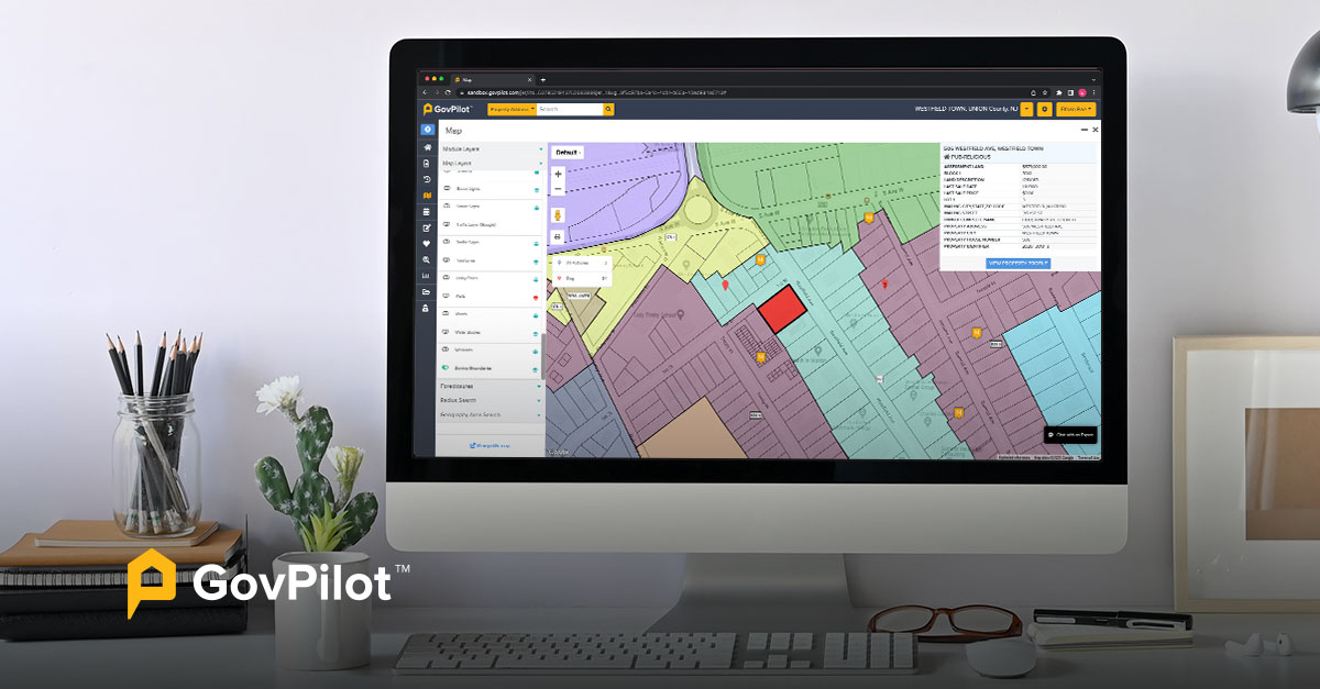
1. Pull up property records in seconds
GIS makes it possible for local health departments to access digital health inspection notes, health licenses, and other relevant property records for businesses, restaurants, food vendors, and housing units in just a few seconds. You can also access these records on site from a tablet or laptop, saving you and customers significant time.
2. Determine the best health testing locations
GIS maps make it easy to identify the best locations to set up local health testing, vaccination sites, and other community health services. Local health departments can take into account factors such as population density, accessibility, and transportation options.
3. Visualize disease trends
With the help of GIS and government analytics, local health departments can track the spread of infectious diseases, such as COVID-19 or STIs, in real-time. By visualizing these trends, public health officials can take immediate action to prevent the spread of disease and create awareness among the public.
4. Monitor community-related issues
Beyond evaluating the risk for diseases, local health departments can monitor areas for other community-related issues, like mosquito control, animal canvassing, pet licensing, and animal intake. Monitoring the number of resident complaints and service calls for a particular issue can help with resource allocation and taking pre-emptive action.
5. Track lifestyle-related diseases
GIS for health can be useful in identifying areas at risk for lifestyle- related or chronic diseases, such as asthma, obesity, or diabetes. There are a number of factors that contribute to life-style related diseases, so GIS technology can consolidate this information for better analysis of the problem. With these insights, health departments can create targeted prevention and education programs.
6. Monitor weather risks and hazards
Local health departments can easily identify areas where residents may be more exposed to environmental risks, like contaminated water, flooding, wildfires, or natural disasters. By visualizing how conditions are impacting certain neighborhoods or demographics, health departments can develop policies, allocate resources, and create targeted interventions to assist those in harm's way.
This same technology is applied in local government emergency management software.
7. Better predict heat waves
Making sure communities are prepared for the intense summer heat can save lives. With the help of GIS maps, local health departments can better predict heat waves using a combination of climate models, historical data, locations of urban heat islands, and heat inequity data.
8. Analyze air quality patterns
GIS maps can help health departments identify areas where air pollution is a problem, or might become a problem in the future. This is possible by using a specific GIS layer to analyze the amount of particulate matter concentration in a given area over time. Analysts can compare air quality trends with other data, such as population growth, poverty rates, or any number of other factors, to determine whether there’s a relationship between them.
9. Monitor the impact of climate change
Local health departments can gain incredible insight on the effects of climate change on their communities. Depending on the risk, health departments can use GIS to monitor virtually all climate related trends, including precipitation patterns, hurricane paths, and even locations of harmful algae blooms.
10. Track man-made environmental hazards
Along with natural hazards, local governments can also harness the power of GIS to identify, track, and analyze the impact of man-made environmental hazards on an area. Hazards such as lead exposures or toxic waste sites can quickly become dangerous, so it’s critical for local governments to immediately identify the hazard and prevent further public exposure.
11. Identify areas with limited resources and access
GIS maps can be used by local health departments to highlight areas with limited access to resources, such as healthcare, social services, transportation, education, and broadband internet access. Knowing this information is critical to improving outreach and ensuring all communities have equitable access to basic services and care. Local governments can also use GIS to identify food deserts, or areas without convenient access to grocery stores or health food options for help forming a local government agriculture strategic plan.
12. Simplify zoning considerations
When zoning, development, and environmental data can be visualized, departments can work together more efficiently and make more informed zoning decisions. When utilizing the same set of data and visualizations, departments can take a holistic approach to zoning that’s in the best interest of the community.
Get more insight into GovPilot’s planning and zoning software.
13. Record the location of seniors and disabled residents
GIS maps can be used to record where senior citizens and disabled residents are located in a community. This information can be used to create targeted programs and services and monitor the growth or decline of these populations. Having this data readily available can assist with resource allocation to ensure seniors and disabled residents have continuous access to the services they need.
14. Map resident concerns and service requests
Local health departments can use GIS to map resident concerns or service requests to aid in quicker response times. Any ‘report a concern’ messages can easily be stamped to a map, so local health departments have a comprehensive look at where resident concerns are concentrated, or if there are patterns to address.
How to use GIS maps to store public health documents
Gaining access to these incredible insights is one of the top benefits of using GIS maps for local health departments. But harnessing the power of data is only possible if data is properly captured and stored.
Public health data management is a critical component of working with GIS data. As technology quickly advances, local health departments need to capture and share vast amounts of public health data into modern, cloud-based government storage solutions.
Modern data storage technology in the government cloud allows local health departments to access public health records and documents anytime and anywhere. Imagine health inspectors in the field using a tablet or mobile field device to upload inspection reports to the government cloud in real-time. In a matter of minutes, health inspection reports can be made available to business owners or colleagues back in the office.
By storing data in GIS databases, health departments can easily access and share data with other agencies and organizations via streamlined government communications channels. GIS software can also allow for real-time updates to maps and datasets, ensuring that information is always current and accurate. Using GIS to store public health documents can help health departments make informed decisions and allocate resources more effectively, which in turn saves both time and money.
Choose GovPilot as your local government GIS mapping partner
Getting started with new technology is usually the hardest part. There are many things to consider, including what you’ll do with old paper records, how to onboard government employees to the new technology, and whether your agency will adapt quickly to new processes.
Thankfully, making the transition to using GIS maps is straightforward. Once your agency starts to experience the countless benefits of GIS maps and public health data storage, there will be no looking back. From automating tedious tasks and visualizing real-time data, to securely storing sensitive public health data and finding cost savings, the benefits of modernizing public health infrastructure cannot be overlooked.
If you are ready to take action to modernize your public health infrastructure with GovPilot, schedule a demo today.
Health Department GIS Map FAQs
How Can GIS Maps Help With Health Inspection Records?
Whenever your local health department performs an inspection of a local business, the records will be automatically uploaded to the cloud and accessible alongside the full set of property records on the GIS map.
Digital government health inspection forms from GovPilot come customized for an array of common business types like retail food inspection forms and aquatic facility inspections.
How Do GIS Maps Help With Health Licensing?
Just like facility inspection records, health licenses and related documentation for local businesses can be pulled up in seconds from the GIS map once as soon as they’re uploaded to the cloud
Here are common digital health license types available with GovPilot government software:
- Child care business license forms
- Day camp license forms
- Pet facility license forms
- Massage parlor license forms
- Food establishment license forms
Read on:
%E2%80%9D-6.png)