Modern Planning & Zoning Software Solutions & Workflows 2023: Everything to Know
In local governance, few departments face challenges as intricate and ever-evolving as zoning and planning. Balancing the aspirations of a community with the complexities of land use regulations can be a herculean task. But in the digital age, a glimmer of hope emerges.
Innovative software solutions have revolutionized zoning departments' operations, promising more optimized processes, improved accuracy, and enhanced efficiency.
Let's explore the transformative potential of such software, shedding light on how it can empower local zoning officials to navigate their complex responsibilities with greater ease and precision, ultimately leading to better, more responsive communities.
What Is Planning and Zoning Software?
Planning and zoning software is a comprehensive and sophisticated toolset meticulously crafted to aid local government authorities in land use and urban development management within their jurisdictions. At its core, this software functions as a digital command center, empowering planning and zoning departments to navigate the complex landscape of land use regulations with ease. It provides diverse features and functionalities, with each facet contributing to a more streamlined and efficient approach to land use management.
It can also facilitate the creation, maintenance, and timely updates of zoning codes and regulations, ensuring alignment with ever-evolving legal requirements. Furthermore, it simplifies permit application processing, offering convenience for applicants and staff involved in the approval process.
At a glance, the core components of planning and zoning software include:
- Geographic Information System (GIS) integration enables the visualization of zoning data on maps, providing invaluable spatial insights for informed decision-making.
- Public outreach and engagement tools, allowing residents and stakeholders to effortlessly access information, contribute feedback, and monitor ongoing projects.
- This software centralizes government data storage, making historical records, reports, and documents related to land use readily accessible. It also facilitates compliance monitoring, empowering authorities to ensure adherence to zoning regulations and take enforcement measures when necessary.
By automating routine tasks and furnishing robust reporting capabilities, planning and zoning software signifies a pivotal shift towards digital modernization in local government. Beyond simplifying processes, it enhances transparency and municipal accountability, fostering more organized, responsive, and equitable communities.
Workflows Optimized by Planning and Zoning Software
As we delve deeper into planning and zoning software's transformative potential, it's crucial to understand how its digital command center optimizes various critical workflows integral to land use management and urban development.
Let's explore these key processes that benefit from the seamless integration of technology.
Land Use Management
Managing land use is at the heart of zoning and planning departments' responsibilities. This pivotal task becomes more intuitive and effective with planning and zoning software. The software allows for easy creation and maintenance of zoning codes and regulations, ensuring they remain compliant with ever-changing legal requirements.
This simplifies the procedure of land use planning, helping local authorities strike a balance between community aspirations and regulatory demands.
GovPilot has partnered with both the ICC Code Connect API and General Code eCode360 API to make it easy for planning & zoning as well as code enforcement department officials to pull up relevant codes in real-time from the local government offices or the field.
Here are Tips for Modern Local Code Enforcement to keep in mind when making sure new and existing structures meet local zoning standards.
Public Space Design
Designing and maintaining public spaces is essential for creating vibrant, livable communities. Planning and zoning software plays a vital role by providing tools for visualizing zoning data on maps, often through Geographic Information System (GIS) integration.
This feature empowers local governments to make informed decisions about public space design, ensuring that parks, recreational areas, and green spaces align with zoning regulations and community needs.
Here are Modern Tips for Parks & Rec Management and a look at how GovPilot software helps the parks & rec department.
Residential Zones
Residential zoning involves the regulation of housing developments within a jurisdiction. Planning and zoning software enhances the permitting and inspection process for residential projects, making housing department workflows efficient and transparent.
It also facilitates compliance monitoring, allowing authorities to ensure that residential developments adhere to zoning regulations. With compliance monitoring, communities are developed to meet housing demands while maintaining the area's character.
Take a look at how the GovInspect app and building permitting software modules help with these solutions pages.
Commercial Zones
While commerce is essential for any community, business demands must always be balanced with the needs of the people. That's where planning and zoning software aids come in. These tools simplify approving commercial projects, ensuring they align with zoning codes.
Additionally, the software provides a platform for businesses to access information and apply for permits, promoting economic development while adhering to zoning regulations.
Learn How to Drive Local Economic Development as a Municipality and How Municipalities Can Partner with Private Businesses.
Site Use Application Reviews
One of the most critical functions of planning and zoning departments is reviewing and approving digital site use applications submitted by developers. The software automates this process, allowing citizens and businesses to submit these applications via your local government websites. Authorities can review the digital application to ensure that proposed projects conform to zoning regulations before approval.
It expedites the application review process, reduces errors, and enhances transparency by keeping all stakeholders informed about the status of their applications.
Public Transportation
Efficient public transportation systems are crucial for sustainable urban development. Planning and zoning software supports transportation planning by providing government data analysis tools.
Authorities can use these tools to assess transportation needs, plan for transit routes, and ensure that zoning regulations encourage the development of transit-oriented communities. As a result, public transportation becomes more efficient, and traffic congestion is reduced, leading to more livable cities.
Here’s How Your Local Government Can Make Your Community a 15-minute City.
Key Modules of GovPilot's Planning and Zoning Software
When exploring the transformative potential of planning and zoning software, it's virtually impossible to avoid GovPilot and its key modules for the planning and zoning department.
These modules seamlessly integrate technology to enhance planning and zoning workflows, making life easier for local governments and creating more organized and responsive communities.
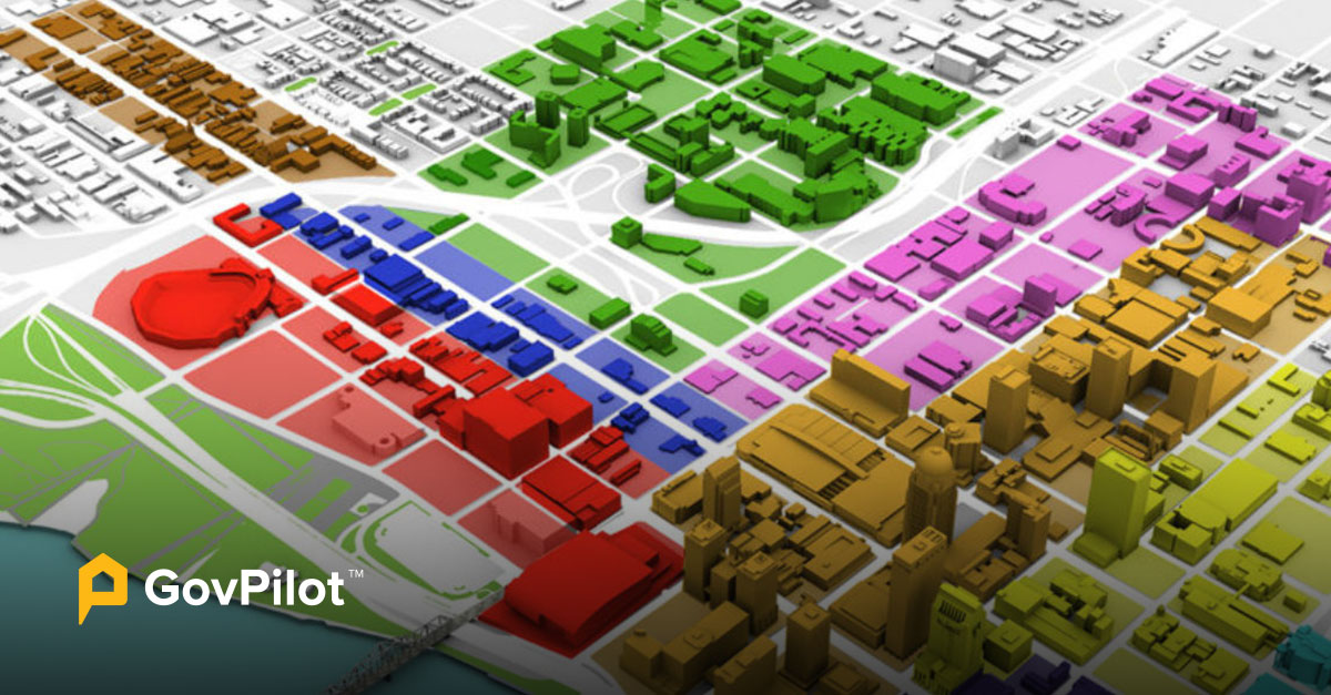
GIS Map for Intuitive Visualization
One of the standout features of GovPilot's planning and zoning software is its Geographic Information System (GIS) integration, which offers an intuitive and visually engaging way to understand zoning data and is automatically accessible with the purchase of any GovPilot pricing plan.
This module provides local authorities with a dynamic 3D map displaying all zoning information, properties, and land-use designations. Zoning officials can navigate through their jurisdictions with a few clicks, gaining valuable spatial insights.
The GIS map module allows for real-time updates and overlays of zoning codes, regulations, and historical data. This capability simplifies the decision-making process, as local governments can easily visualize how proposed developments align with zoning regulations and community needs.
GovPilot's GIS map module empowers planners to make informed decisions about land use management and public space design by providing a clear and interactive representation of zoning information. Learn more about GIS for Government & Its Various Use Cases.
Digital Land Use Application Submission and Approval
In the digital age, manual paperwork and lengthy approval processes are becoming a thing of the past. GovPilot's planning and zoning software incorporates a module for digital land use application submission and approval.
This module simplifies and speeds up the application process for developers, residents, and businesses, making it efficient and user-friendly.
Local authorities can accept and process land use applications electronically, eliminating the need for physical paperwork. Applicants can submit their proposals online, track the status of their applications, and receive notifications when decisions are made.
This saves time and enhances transparency by allowing all stakeholders to stay informed throughout the application process. With this module, local governments can efficiently manage the influx of applications while maintaining compliance with zoning regulations.
Digital Construction Permitting Workflows
Construction permitting is a complex and highly regulated aspect of planning and zoning. GovPilot's software offers a specialized module for digital construction permitting workflows, catering to the needs of contractors, builders, and local authorities.
This module automates and enhances the permitting process for various building projects, ensuring compliance with zoning codes and related requirements.
Contractors can apply for permits online, submit necessary documentation, and schedule inspections through the platform. Local authorities can review applications digitally, speeding up the approval process and reducing errors.
Moreover, this module enables easy construction progress tracking, ensuring all work aligns with zoning regulations. It simplifies the complex web of requirements associated with construction permitting, promoting economic development while maintaining zoning compliance.
Here’s How Permitting Software for Local Governments Works.
Street Opening Application for Business Growth
GovPilot's planning and zoning software includes a Street Opening Application module to encourage economic development and simplify business activities. This feature allows businesses to generate revenue by utilizing sidewalks or closing streets for specific events or activities.
Local governments can receive and process street opening applications digitally, making the process more accessible for businesses while ensuring safety and zoning regulations are met. GovPilot's software promotes local businesses and fosters a vibrant community atmosphere by facilitating this process.
Incorporating these critical modules into their planning and zoning operations, local governments can harness the power of technology to navigate their complex responsibilities with ease and precision.
GovPilot's software empowers local zoning teams to efficiently manage land use, streamline application procedures, promote economic growth, and visualize zoning data—all while adhering to regulatory requirements.
These modules represent the future of local governance, driving digital modernization and fostering more responsive, organized, and equitable communities.
General Benefits of Government Software for the Zoning Department (and Every Municipal Agency)
While we've explored the specialized modules that make GovPilot's planning and zoning software a game-changer for local governments, it's crucial to recognize that government software, in general, offers a broad spectrum of advantages that transcend departmental boundaries.
These benefits are instrumental in shaping more efficient, accountable, and responsive administrations.
Public-Facing GIS Map for Enhanced Transparency
The benefits of GIS maps are certainly evident, but not just limited to, the local zoning department. Every department / individual can benefit from taking a look at the multilayered 3D map of their neighborhood.
With a few clicks, residents can explore the zoning designations in their neighborhoods, understand land use regulations, and stay informed about local development projects. Government software fosters greater engagement and participation by making this information readily available to the public.
It empowers citizens to be active community stakeholders, contributing to a more inclusive decision-making process and aligning government actions with community needs.
Cloud-Based Government Data Storage for Accessibility and Efficiency
The shift towards cloud-based data storage for governments has revolutionized how municipal and county departments manage information. Government software often leverages cloud technology to centralize data storage securely. This approach offers several advantages, including accessibility, scalability, and disaster recovery.
Cloud-based public sector software enables authorized personnel to access crucial data from anywhere with an internet connection, promoting collaboration and efficient municipal remote work. It eliminates the need for extensive physical storage and simplifies data retrieval. Moreover, the cloud's scalability ensures governments can adapt to changing data storage needs without significant infrastructure investments.
In addition to accessibility and efficiency, cloud-based storage enhances government data security by implementing robust encryption and backup solutions, safeguarding sensitive government information against threats and disasters.
GovPilot has partnered with Microsoft Azure to offer cyber secure digital data storage for municipalities. Explore this resource for more info: What is the Azure Government Cloud & What are the Benefits?
Real-Time Data Analytics for Informed Decision-Making
Government software equips decision-makers with real-time data analytics capabilities. Government departments can promptly make informed, evidence-based decisions by leveraging data-driven insights. This proactive approach optimizes resource allocation, enhances service delivery, and identifies areas for improvement.
Real-time data analytics provide the agility needed to swiftly respond to emerging challenges and trends. For example, in planning and zoning, authorities can use analytics to track shifts in housing demand, assess the impact of commercial developments, or identify areas needing improved public transportation infrastructure.
This data-driven decision-making fosters more responsive governance and facilitates better outcomes for communities.
Cybersecurity for Data Protection
In an era of increasing cyber threats, government software prioritizes cybersecurity. It implements robust security measures to safeguard sensitive government data, protecting it from unauthorized access, breaches, and cyberattacks.
Cybersecurity measures encompass multiple layers of defense, including firewalls, intrusion detection systems, encryption, and regular security updates. These measures not only protect government data but also preserve citizens' trust in the security and privacy of their information.
By prioritizing cybersecurity, government software reinforces the integrity of government operations, maintains compliance with data protection regulations, and upholds the confidentiality of sensitive information, ultimately contributing to a more secure and resilient governance infrastructure.
Incorporating these generalized benefits into government software solutions amplifies the positive impact across all departments. These advantages transcend specific functions and create a foundation for efficient, accountable, and responsive governance that benefits communities.
Here are helpful cybersecurity resources for your municipality:
- Government Data Breach Examples & Lessons
- How to Train Government Officials on Cybersecurity
- Local Government IT Disaster Recovery Planning
Embracing the Future of Local Governance
The benefits of government software extend beyond specific departments. Public-facing GIS maps, cloud-based data storage, real-time data analytics, and cybersecurity measures are instrumental in creating efficient, accountable, and responsive administrations that benefit communities as a whole.
Now, the call goes out to local planning and zoning departments: Embrace the future of local governance. Embrace the transformative power of planning and zoning software. Embrace the opportunity to revolutionize your operations, enhance your community's livability, and pave the way for a more organized, equitable, and responsive future.
Book a 15-minute consultation with GovPilot to get started.
Local Planning & Zoning Department FAQs
What is Planning and Zoning Software?
As the name implies, planning and zoning software is government software that streamlines and automates planning and zoning department processes to save time and money. This tech enables constituents to quickly and conveniently file for zoning related permits directly through your website at any time through any mobile or desktop device. Then your government officials can review and fulfill requests directly in the system and automate email responses to keep the requester informed.
What Does the Zoning Department Do?
Zoning department software is able to perform a variety of tasks within the government department including: automating task assignments & inspection scheduling processes, electronically managing requests in a searchable cloud database available to employees across all departments, and utilizing 3D GIS Mapping technology for city planning.
How Can the Zoning Department Improve Its Workflows?
By modernizing and automating once time consuming, manual processes such as, inspections, digital zoning and permit application reviews, and task scheduling, the zoning department of your local government will see improved workflows.
What Are Key Features of Planning & Zoning Software?
Planning and Zoning software aims to save your municipality time and money by simplifying tasks, streamlining workflows and organizing project timelines. Key features of planning and zoning software include digitized applications for zoning permits and 24/7 online application acceptance through your government website. Constituents and contractors will appreciate the convenience of these online forms and automated updates delivered in real-time through text message and email. These notifications will alert them of the status of applications, reviews, inspections, and permits.
Read on:
- AI in Government in 2023 and Beyond: Bringing Artificial Intelligence to Your Municipality
- Future of Government: Technology & Public Policy Trends Shaping the Public Sector With GovPilot
- Customer Experience (CX) in Government: Transforming Local Government Citizen Relations
- 15-Minute City Guide for Local Governments: Making Municipalities More Accessible
- How Mobile Devices Are Transforming Local Government Work in the Field 2023
- Local Government Vacant Property Management: Combating Blight and Driving Economic Development
%E2%80%9D-6.png)