In our digital age there is no shortage of data available that can help local governments make informed decisions to improve their communities. For many governments however, that information can be fragmented and siloed across a number of departments, or unavailable to the public for which it might be useful.
From positive Coronavirus cases, to code violations to property sales and new business registrations, much of the information cities manage is associated with specific addresses. That makes Geographic Information Systems (GIS) an effective way to both organize data, and visualize it to enable better decision making.

GIS does more than just store data – it makes that data transparent and accessible to the public while helping to provide a clear view of actionable patterns that are impossible to see otherwise.
Here are four reasons for local governments of all sizes to embrace public-facing GIS mapping:
1. Provide Residents with Accessible, Visual Information
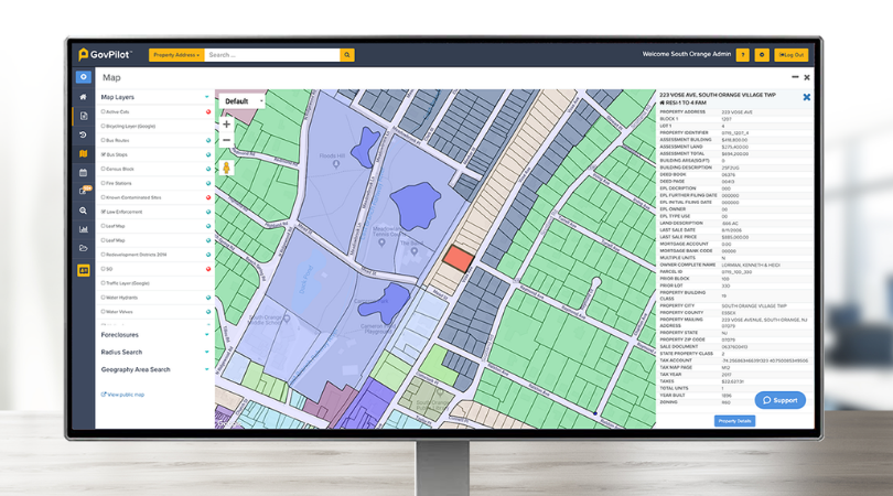
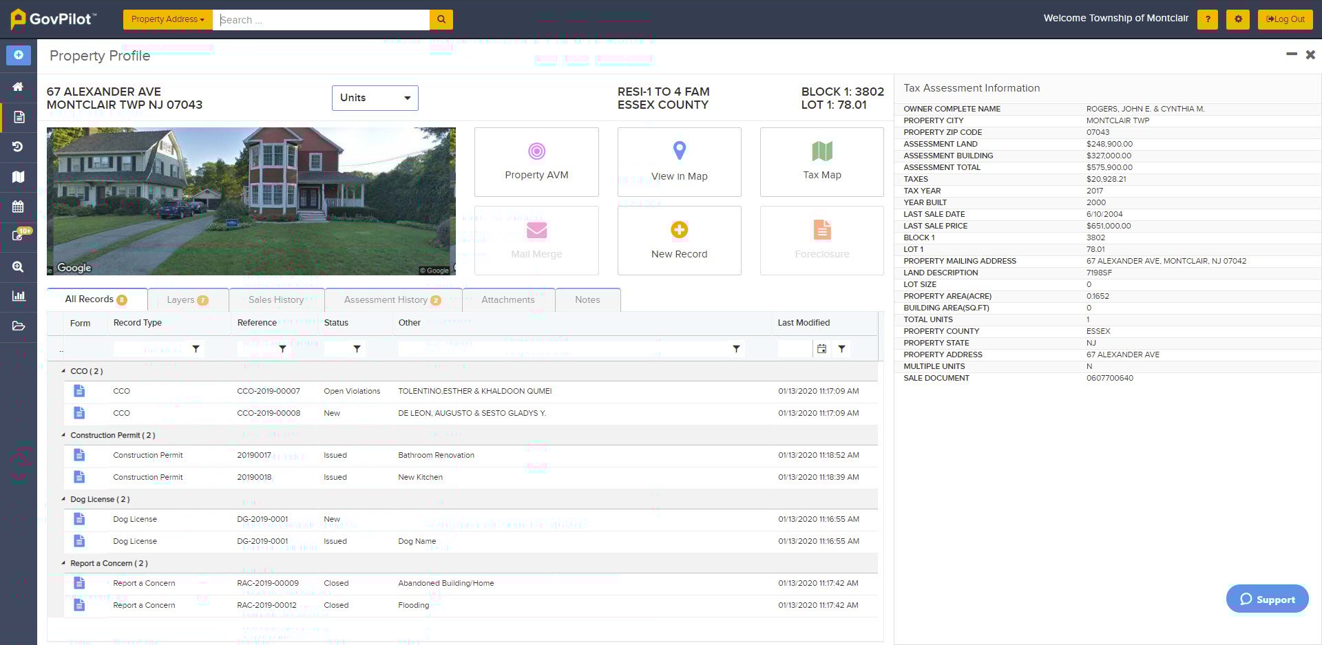
A public-facing GIS map, available via a municipal or county website can serve as a one-stop repository of critical information for residents and local businesses. This easy access to visualized data puts useful information at the fingertips of constituents who can use it to quickly get the answers that they need. A GIS map displaying voting districts helps residents understand where their polling station is located. A map with a flood zone layer, can help home and business owners become more resilient by purchasing flood insurance. GIS map features such as GovPilot's Property Profile can also display parcel-specific detail such as ownership, tax assessment information, and even outstanding permits or code violations.
Recently, GIS maps have played a critical role in visualizing data related to the COVID-19 pandemic. Color coded GIS maps are an excellent way to display fast-changing, detailed data over widespread geographic areas - from entire countries, down to individual municipalities. This type of real-time visualization can help health officials make nuanced policy recommendations and the public appropriate action.
2. Communicate Quickly with Constituents
While a public-facing GIS map makes information easily accessible to the public, and cut down on phone and in-person inquiries, there are instances in which a GIS map can be used as a communication tool to interact with residents.
Are you planning to close a road for resurfacing or sewer line maintenance? GovPilot’s GIS can be used to send advance notifications to all property owners along the route. Has your community updated its flood maps? Create a mail merge in just a few clicks to inform citizens.
 Public-facing GIS maps also enable residents to engage with their government directly. For example, GovPilot’s GovAlert mobile app allows constituents to keep their community safe and livable by reporting non-emergency concerns such as a pothole or a noise complaint. As these concerns are aggregated, local governments can dispatch the appropriate service to address the concern, leading to increased constituent satisfaction and safety.
3. Drive Economic Development & Allocate Funds According to Need
When the capital city of New Jersey, Trenton sought to provide emergency financial relief to local businesses amid the COVID-19 outbreak, it made funds available to businesses within the “Urban Enterprise Zone”. Created by the New Jersey Legislature in 1983, Trenton’s Urban Enterprise Zone Program was designed to help stimulate new economic activity and reduce unemployment within its boundaries.
With the Urban Enterprise Zone (UEZ) displayed on Trenton’s GIS Map, local business owners were able to understand if they were eligible for a low interest loan, and apply via a GovPilot digital form, in just a few clicks.
4. Make Communities more Resilient and Speed Disaster Recovery
The Atlantic hurricane season begins on June 1st and runs through November 30th. This year’s storm season is predicted to be particularly active. Elsewhere, wildfires are a threat in the west, and tornadoes and flooding are a persistent concern in the south and midwest.
Pre-disaster resilience and an efficient, organized response, are key factors in a community’s long-term recovery. Public-facing GIS maps with data layers displaying up to date flood zones, evacuation routes, and emergency assets like shelters enable residents to understand and mitigate their risks before a disaster strikes.
Following a disaster, GIS mapping can enable a local government to conduct rapid damage assessment in real-time, and produce an accurate rebuilding cost estimate for the State government, Congressional Delegation, FEMA, HUD, and other relevant agencies such as the Small Business Administration and National Flood Insurance Program.
The sooner an accurate damage assessment and unmet needs estimate is provided to State and Federal authorities, the sooner recovery funds can be disbursed, shortening recovery by months or years - which in turn saves dollars and lives over the length of the recovery.
Ready to Visualize your Data with a Modern Public-Facing GIS Map?
Schedule a 15-minute consultation with GovPilot today to see how our user-friendly GIS lets you easily perform spatial analysis, make smarter decisions, and keep constituents informed - no license required.
%E2%80%9D-6.png)