Across the globe, local governments are using geographic information systems (GIS) to engage citizens, deliver improved services, and inform their decision making. GIS can be a powerful tool to analyze and understand the vast amounts of location-based data that local governments collect. Its uses are varied, from giving law enforcement agencies the ability to spot trends and come up with effective strategies, to helping citizens make use of their city’s open data.
GIS can be a game changer for municipal governments, but in order to successfully implement it, organizations need to have a clear understanding of business objectives and needs. To get your GIS plan started, first consider these six questions.
1. Which departments will use the program?
As GIS programs have gotten more robust, multiple departments are now using them to manage and analyze data. Traditionally, many departments have maintained their own databases, creating opportunities for human error and communication bottlenecks as information was requested across departments and updated in individual silos.
When thinking about GIS programs, consider its uses across multiple departments. Are there ways in which current processes around databases and information sharing can be streamlined?
Read more: Bring Your Departments Together with GovPilot
2. What’s the technical knowledge of the average user?
Traditionally, users of GIS programs needed to have technical expertise in order to manage and operate the program, though these days many GIS interfaces (like GovPilot) are accessible to novice users.
What are your organization’s needs? Will most users (and administrators) have advanced training in GIS? Or will the majority of users require an intuitive user interface that’s easy to understand and operate?
3. Do you require the program to be mobile?
The need to access and update information on the go is increasing as mobile devices allow government workers greater connection while on the go – and mobile applications of GIS are keeping up. Will your government’s field case workers require the ability to view the most up-to-date information on a property, or to add information while in the field? Will your public-facing GIS maps need to be viewable on mobile devices?
4. How will departments use GIS?
Conduct a needs assessment for all departments who will be using the GIS system, and list the potential city-wide benefits and applications. Some examples:
- View the current status of city-wide cases on a map
- Perform a Radius Search and send notifications automatically with mail merge functions
- Compile reports based on historic or current property data
- Visualize critical data such as incoming building applications, public complaints, health issues or vacant properties.
Read more: 5 Innovative Ways Municipalities Use GIS
5. How will citizens use your GIS?
Many municipalities use public-facing GIS to inform and engage citizens. Consider the use cases of citizens as well as government employees. Some examples:
- Get access to historic property data without having to request through the clerk’s office
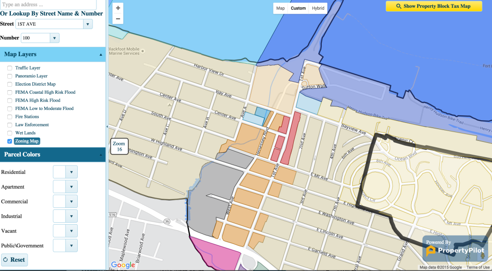
- Be informed with maps for zoning requirements, planned infrastructure improvements, and emergency routes
- Search for facilities like schools, parks, playgrounds, and hospitals
Read more: How GIS Can Close the Citizen Engagement Feedback Loop
6. How will you implement the program?
Develop an implementation plan to meet your use case objectives. This includes looking at what pre-loaded data will be required, based on the use case scenarios you identified.
Will you need to hire an outside firm to help implement the new program? Will you work directly with the company for implementation help? Do you have the resources to implement it on your own?
Need help developing a plan? Our experts are here to assist.
Govpilot’s GIS is built to both user-friendly and high-performance. Users will be able to harness the benefits of GIS without the steep learning curve, expensive 3rd party licenses and requisite years of technical training.
As well as being easy to implement, GovPilot also comes pre-loaded with many of the data sets city governments require, such as property assessment records, FEMA flood maps, emergency service locations, and Google real-time traffic.
[et_bloom_inline optin_id=optin_0]
Curious? Request a demo today.
%E2%80%9D-6.png)